
Monday, September 23, 2013
First Fall Rain Ride 2013
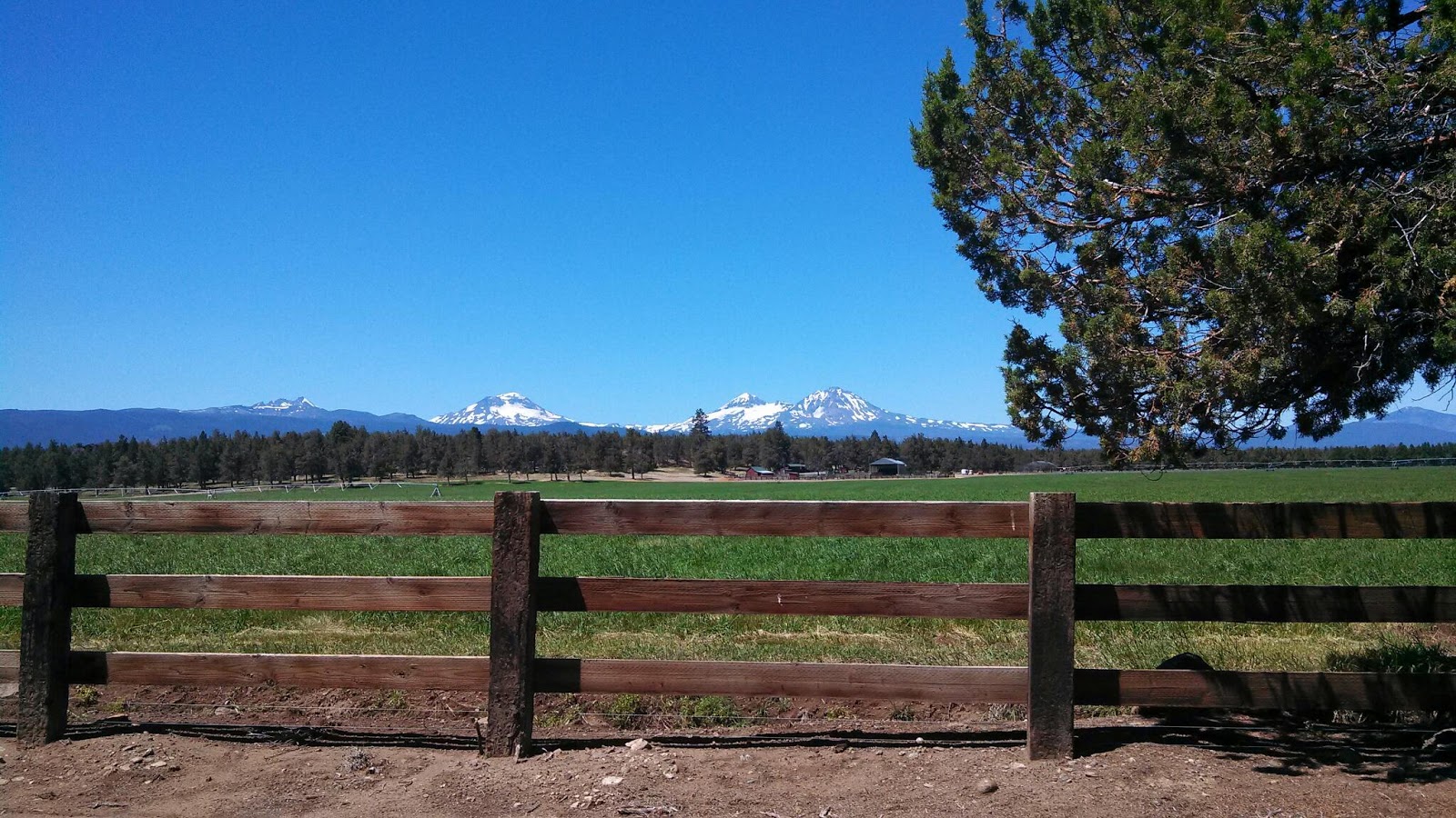
First good rain ride of the season! Luckily I reinstalled my fenders a few days before.
Thursday, August 1, 2013
The Long Way Home (Day Thirty-one)
Morning comes slowly at the feet of giant trees. After raven's "quark quark" wake-up call, I exited the forest depths to the bright riverside and filled my canteens. Slowly making my way back to my stowed bicycle, I scrambled over and under the enormous dead wood of old growth forest. Packed up, I found pavement once again and began the twisting ride along the Clackamas river towards Estacada. After 40 miles of deep forest blankets piled against clean river, I reached the North Fork dam and made the transition into a predominantly human-built environment. Tree farms, agricultural fields, and eventually the non-motorized Springwater Corridor, I returned home to find the first blackberries just ripe.


Wednesday, July 31, 2013
Breitenbush Hot Springs (Day Thirty)
The waters were calm as we paddled our way back to the mainland. Heaving the canoe up the steep shore, we returned it to its resting place and turned our minds to our own rest. We had reservations at Breitenbush Hotsprings!
Throwing our gear in our friend's truck, we had the luxury of riding the gently climbing road towards Breitenbush unfettered. Deep green forest waved softly from all sides as we skimmed past on the smooth pavement. Reaching the turn-off for Breitenbush, pavement turned to dusty gravel and our final destination couldn't come soon enough.
Almost as dusty as the coated plants on either side of this road, we finally arrived, found more friends who had agreed to meet us there, and the now party of five began our tour of the many pools at Breitenbush! Warm pool, warmer pool, cold shower, hot pool, cold river, tepid pool... we strolled around and sampled all the resort had to offer. Set in forest and meadow, the developed but still natural-looking pools were idyllic.
Particularly transcendent is the hot, silent pool. Soaking in the stone pool, water nearly too hot to stand, we gazed over sunny, open meadow and listened to the hush that fell over the whole scene. This area is designated as "no talking" and it was more fun than one might expect.
At this point in our trip, it felt as though we were in Portland's backyard. We were practically within shouting distance of home. Afterall, what's 100 miles over familiar terrain compared to nearly two thousand over unfamiliar? I had an agenda for the rest of the trip, and it included visiting several of my favorite places. Kevin had not been infected with the peculiar deep woods spell of these unique spots, for him they were yet to be discovered. The hot springs however had done their work. Fully relaxed and drained of motivation, Kevin yielded himself to the Portland-bound passenger seat of our friend's car and made fast tracks back, arriving home that evening.
But I couldn't be swayed. I had to ride this next section. (Likely long, restful naps in Bend provided the energy to give substance to my determination...)
After a lift of several miles towards Portland along the Clackamas river, I situated my gear (entrusting many items and pounds to Kevin, I'd travel light for the final stretch), and watched everyone drive away. Alone, I hid my bike and riding gear in a dark section of forest, slung a small pack to my back, and started along the abandoned road. It wasn't long before I was lost in the woods.

Tuesday, July 30, 2013
Piety Island (Day Twenty-nine)
The sky lightened to a weak blue, and we were on our way. Soon the small town of Detroit greeted us, where we found Kevin's grandparents and a delicious breakfast. Now within range of Portland, we called a friend to help us tackle the next adventure - camping by boat.
In a borrowed canoe packed with three adults, one giant watermelon, and a cooler full of beer, ice, and food we set out on the waters of Detroit Lake, a large man-made reservoir that is a popular recreation spot. Testing our mettle and paddling skills, we first maneuvered up the Breitenbush arm. After gaining confidence in the calm waters, we struck out for Piety Island.
Between us and the boat-in campsites lay one third league of motor boat churned water. Would our heavily laden craft survive? Could we turn the boat quickly enough to avoid being swamped? Luckily our path was perpendicular to most boat traffic. Our fearless captain rallied us on, we paddled ferociously, and arrived in the calm bay of the island with only a small amount of water in the bottom of the boat.
Watermelon crackers (melon as cracker stacked with cheese and turkey is delicious) and fire-roasted corn and potatoes highlighted the evening. We fell asleep around the cracking coals of the fire, only to be disturbed by curious deer inspecting our campsite and stumbling around in the bushes. We rest assured in the belief that mountain lions and bears don't swim.


Saturday, July 27, 2013
Over Santiam Pass (Day Twenty-eight)
Refreshed from our rest days, we left Bend at a brisk pace and soon arrived in Sisters after many scenic miles through dry forest at the foot of the eastern Cascades. In Sisters, we mentally and calorically prepared for our ascent of the Cascade mountain range. Still debating whether to cross at McKenzie pass or Santiam pass, we observed the intersection where the Santiam and McKenzie highways meet. McKenzie is the lower traffic road, but Santiam has a consistently wide shoulder and was a more direct route to our destination.
Choosing Santiam, we wound our way upwards through the dry forest and sunlight. The forest opened as we neared the pass, the sun further heating us as we steadily gained elevation. Respite came in the form of a small, shady roadside waterfall where we dunked our heads and filled our water bottles. Soon we stopped again at an overlook with a view of Mt. Washington and Black Butte. Interpretive signage discussed the B&B Complex fires that burned the area in 2003, and also gave a neat clue as to the reason for the shapes of the visible high peaks. Mt. Washington is a stunning glaciated volcanic mountain with steep sides of bare rock, while Black Butte is a smooth cone with gradual forested slopes. Perhaps because of its highly eroded state, it might seem that Mt. Washington is the older volcano. Actually though, Black Butte is older. Further west, Mt. Washington bears the brunt of Pacific moisture, gathering glaciers that cut its sides. Protected in the rain shadow of the Cascades, Black Butte stays glacier free and retains its smooth sides. Cool!
Hardened by the passes we climbed in Idaho and Montana, we reached the top with breath to spare. Gathering speed, we dove down the western slope into dense forest. As we picked up the North Santiam highway that leads to Detroit, the forest grew denser. and darker. and deeper. and greener. Traffic was light, the pavement was smooth, the shoulder was wide, and the evening sun winked through the trees. It lit brilliant rooms of trunk and moss and fern, and it filled the rushing water of streams and tiny falls with bright confetti. Still several miles short of Detroit, we lay our heads to rest on the mossy, flower-speckled ground of a retired road and fell asleep on the wet west side.


Friday, July 26, 2013
Bend the Beautiful (Days Twenty-six and Twenty-seven)
The next two days were filled with food and relaxing. Walking and biking around Bend (pop 79,000) in the warm, sunny weather was like entering a sort of paradise. A sticker for sale demanded: "Be nice, you're in Bend" and the city lived up to it. Enjoying tempeh, kombucha, multiple self-serve frozen yogurt bars, and Deschutes brewery, we deliciously replenished ourselves. In the bends of the Deschutes river that give Bend its name, people floated on the slow-moving water. In kayaks and on paddle boards, but mostly in clumps of brightly-colored inflatable rafts they drifted along. Under the bright sunshine and set against the naturally swampy and grassy banks of the river (Bend seems to consciously promote habitat within city limits, even retaining large snags near the river), the scene was surreal. 

Wednesday, July 24, 2013
Across Oregon in One Day (Day Twenty-five)
The day dawned bright, and we were ready to find a fast way back west. While the central Oregon forests still awaited exploration, the past (nearly) month and thousand-odd miles had left us low on energy and time. Our enquiries told us that buses ran from Ontario to Bend, but bikes would need to be boxed (each large single-use cardboard box costing $15), we'd need to stay in Ontario for the next day's early morning bus, and of course tickets wouldn't be free. So with a mountain of positive interactions involving random folk behind us, we decided to use the most extensive national public transportation system that exists - hitchhiking.
A tailwind was blowing, and with the ambitious goal of Bend in mind, we decided to begin our day with a nice warm-up ride to Cambridge. About 15 miles later, after a soaring downhill with enough tailwind to balance our own forward motion and make the air still around us, the smooth ride soon became bone-jarring. Meet the Pulverizer. This giant machine rips up pavement in preparation for resurfacing, leaving behind baseball-sized gravel and the worst wash-boarded strip of terrible you may have ever seen. Bringing all of our loose surface bike-handling skills to bear, we shook the last several miles into Cambridge. Covered in dust, we stumbled into a small coffee shop, met Davy, and had cold drinks. Once recovered, we crossed the street to a restaurant to ask about the Weiser River Trail. Like so many rails-to-trails projects, it shows up on Google maps as an enticing green line, but without information on its surfacing. If paved, these trails separated from traffic are a dream to ride. While not seeming very familiar with the trail, local folk agreed that it was not paved. With that information, our recent dusting and shaking, and the heat of the day reaching a crescendo, we decided to begin seeking motorized assistance.
Stationed just outside Cambridge, we caught a ride with record speed. Vaughn James let us put our bikes in the back of his truck, then let us know we were "smart" for catching a ride in the heat (~102F) and that we smelled like "river folk". Picking his friend up a few miles later, they were on their way to build a waterwheel. With big truck, cowboy hat, and friendly yet challenging manners, it was nice to meet these two guys before we quickly left this agricultural area of Idaho.
Dropping us off just shy of the Oregon border, we quickly rode over the Snake River and into a wide bike lane. "Welcome to Oregon, here's your bike lane!" Kevin coined and we repeated happily as we enjoyed the designated bike lanes and wide shoulders of our home state.
After threading our way through Ontario, we put ourselves on the Central Oregon Highway (20) and hoped for a ride. Several minutes later, hot and bored, we decided to ride on to Vale. One enormous fruit smoothie later, we pedaled a few miles beyond Vale and stuck our thumbs out once again. Perhaps here most traffic would be long distance, and we could get a ride into Bend. No such luck. Knowing that eventually someone would be able to give us a lift, but unwilling to stay in a spot that wasn't working, we jumped back on our bikes. Utilizing a technique developed on the way to Phoenix, we rode with our thumbs out (using the right arm of course, and keeping limbs out of traffic).
Soon a truck pulling an enormous fifth wheel RV came by. Slowing as it passed us, it then stopped a ways ahead. Unsure whether the driver was stopping for us, we slowed but continued past. Again the RV passed us, then stopped ahead. This time we stopped too. Yes, he was stopping for us, but wasn't sure where our bikes could go. Removing the front wheels and minding the large, shiny face of the RV, we worked the bikes into the bed of the truck and secured them. Jack was delivering the RV from Indiana to Medford, OR, and could take us all the way to Bend! For the next several hours, Jack and his small, fluffy dog Princess kept us entertained with stories of artifacts old (cars, coins) and older (arrowheads), and where they could be found.
Admiring the central Oregon sagebrush and juniper scenery, and not quite believing we had ridden 100 miles of this road in December, we pulled into Bend soon after dark. Welcomed into the home of friends we had met at Sunbeam Hotsprings, we soon feel asleep after a long day's travels.


Wednesday, July 17, 2013
Down and Out in Idaho Country (Day Twenty-four)
After a long sleep in the home of our unexpected new friends, we bid farewell and rode into downtown McCall. Breakfast and groceries later, we began our day by heading west out of town on highway 55.
Despite our varied experiences and accumulated fatigue over the past three weeks, this next section of highway was a real thriller! Steep downhill of winding curves, the highway signs warned motorized traffic not to exceed 25 mph in many sections. Nearly keeping pace with other traffic, we (almost) literally screamed into New Meadows.
Skimming down the straight main street, touring cycles were spotted outside a cafe. Soon we had found their owners within and ordered the best malts of the trip. The middle-aged couple had come from the Hells Canyon direction, and were considering riding to McCall. We strongly recommended NOT riding into McCall from the west due to the steep, narrow, winding uphill (and stand by this recommendation, unless motorized traffic manages to be absent). After a conversation mostly about their sailboat, we were on our way.
Next we rode our bikes. And kept riding. Small hills were challenges. The slight headwind was maddening. Yes, limits were being reached... For twenty-two of the past twenty-three days we'd pounded cleat to pedal, major muscles burning untold calories. Would we ever make it back to Portland, or even to Oregon?
Searching for a shady lunch rest stop, we ended up in a wooded flat spot near the crest of a hill. Here the highway cut through National Forest, and here, due to steep hillsides and guard rails, no car could stop. Lunching and munching, Kevin heard a crunching... bear! Quickly standing, we watched as the black bear crossed the road towards us and with admirable speed scrambled up the adjacent steep, brushy hillside. Popping up over the guard rail on the opposite side of the road, she was probably accustomed to waiting for gaps in traffic, but not to finding random cycle tourists.
Cresting one more hill and leaving National Forest behind, we flew down into farm country and eventually landed in the town of Council. Sitting in a patch of thick grass graced with evening sun, and with access to the interweb once again, we informed our vague notions with cold facts. Where could we catch a bus west? Amtrak, greyhound, local line? From Ontario, Baker City? Would bikes need to be boxed? Many questions still unanswered, we fell on the more immediate issue of the lateness of the day. Could we camp along the Weiser River Trail? Should we try to catch a ride into Ontario, where morning buses depart from?
Tired and still with no clear direction, we decided to take the easy, simple route- a box (motel), but with a caveat. With the maximum price we were willing to pay set at $40, we walked into the Starlite Motel. $45 for a room we were told. Maybe our resolve was evident, because soon we were made a second offer- $40. Satisfied, we scurried into the pre-made shelter to watch the brush and grass-covered hills turn pink and windy in the twilight.


Unexpected Hot Showers (Day Twenty-three)
The sun warmed us amongst the tall Ponderosa. Almost done packing we were greeted by the camp host who reminded us of the mysterious hot springs shower. "If you don't walk in the river you're not there," he explained. Our gear was packed in minutes.
The well worn trail skirted along the Payette leading to a high pool on a rounded escarpment. We soaked in the shallow pool admiring red, green, and black biofilm before heading towards the shower. A submerged causeway of stone led between the cliff face and a large eddy in the turquoise river. We waded through the icy waters to another sandy beach. The great rock face above us exuded red and black snot that hung down in long strands. Rivulets of geothermal water ran over the shining stone. Below, the small slope of river deposit had been organized into a few cascading pools fed by a 20 foot waterfall of steaming liquid. We alternated roasting in the waterfall and cooling off in the gentle eddy. Thoroughly relaxed we returned to our metal steeds and powered up the hill.
The Banks-Lowman road continued high above the river. Soon the forested hillside gave way to rocky cliffs and we dropped along the canyon walls. Out of the protective shade the sun's rays baked us as we rode on to Garden Valley. We found the Garden Valley Market and quickly dominated a cafe table with our mountain of food. Finally we ate the 5-serving tuna can found in Montana by way of taco buffet. We conquered a bag of cheetos and wrote. Eventually it was time to brave the heat again and finish the descent to Banks.
We were met at the crowded intersection with an exodus from the North towards Boise. Relief from the heat was close at hand in the North fork of the Salmon. The cooling refreshment spurred to try and hitch North to McCall with such heavy traffic. We positioned ourselves in a nearby gravel lot and stuck our thumbs out. Soon enough a red van approached us and we met Toni, her dog Bo, and a blind bobcat named Woody. Toni, a wildlife rehabilitation specialist, graciously drove us to McCall and insisted on dinner on the town with her husband Rich. We happily fell asleep on a spare bed in a delightful food coma.


Sunday, July 14, 2013
Stanley, ID and Banner Pass (Day Twenty-two)
Camped only a few miles from Stanley, we decided to wake early and have breakfast in town. The sun was just beginning to find its way into the shallow river canyon as we made our start. Not waiting for warmth and light to find us and melt the frost from the outside of our sleeping bags, we set out on the nearly empty and still road. A few more miles following the Salmon upstream, and we entered Stanley, a small town with the grey, jagged teeth of the Sawtooth Mts. creating a dramatic backdrop for the high-elevation valley.
We rode circles around the town- deciding which of the cafes might have the best breakfast, restocking at the small mercantile, visiting tourist info for tips on road conditions, checking the gear shop for Da Brim (Hank had this fabulous helmet-specific hat as we rode north from Jackson, MT), and a final ice cream stop before heading west out of town towards the Sawtooths.
Assured that the wind from the west would cease as we left the valley, we pedaled out with optimism. Barely stopping, we powered our mechanized vehicles more than 20 miles to the top of Banner Pass. While not completely headwind-free, trees (their abundant presence long-missed) helped break the wind. At the top we stopped for a break in the shade, swatted at a few giant biting flies, and suffered comments from speedier two-wheeled vehicles (motorcycles).
Launching from the top of the pass, we dropped quickly and then joined the Payette River in its more gradual descent. Glimpsing the turquoise liquid shining and twisting, we took the first opportunity to dunk ourselves and wash off the heat.
Continuing to Lowman, the store/cafe stop we had been talking did not appear so we continued following the Payette west. Several miles later we eyed a riverside gravel pull-out and were considering its campsite potential when suddenly a large black pick-up pulled from behind the tall hill guarding the gravel road. Spooked, I was sure I'd seen this pick-up pass us at least twice today. But after quick chat we learned that this was National Forest land, that he was hunting rocks, and that there was a campground just up the road, with hotsprings at that.
Pine Flats campground appeared as a descent to the left. Swooping and switchbacking, we pulled into the large, populated campground. One ride around the loop told us there was no vacancy. Considering our options, we walked down to the river's edge. We could stealth camp, or meet people who would share their campsite with us. We could not ride the hill back up to the road tonight, and we needed to eat dinner right now. Cooking over our tiny alcohol stove near the trailhead to the hot springs, the camp host came over to enforce fire safety and let us know that while the people in 6 had also reserved 7, it was not being used.
Dinner consumed, we went to ask if we might occupy the unused campsite. Yes, of course! They said. Oh, but that was 8... over to 6 and another affirmative, along with a campfire invitation. Necessity is the mother of invention, but perhaps also of friendship... soon we were sharing a campfire with people from a company (Coldchain) that makes energy-efficient, bullet-proof freezer doors about to raft the Payette river. Learning more about the Payette river, morel mushrooms, and south African animals than we could have dreamed, we eventually headed back to our own spot under the star-spattered sky and fell asleep.


Subscribe to:
Posts (Atom)